It appears to me there is confusion as to who owns the Alley. I have never seen a deed transferring the Alley to the Subdivision from the developer. If the reliance is on the plat and indenture then Parkview has an easement for use of the alley, they do not own it, but have a right to use it.
Here are the what the Agents who represent Parkview (simply referred to as “Agents”) claim with what we have discovered. This based off of the Q&A supplied by the Agents.
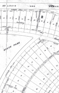
The agents contend that, unlike the rest of Parkview, the Westgate alley was/is the sole possession of the Beredith Realty Company (the Parkview Neighborhood). The evidence as stated is from a plat map from some time after 1959. This plat map is not a current survey nor a survey from the 1926 era when the development of the neighborhood was finished. I am not sure why it was chosen. A current survey should be made. Apparently, There is a difference between the way the Westgate alley was drawn and the way the rest of the neighborhood alleys were drawn that the agents contend supports their theory.
Claim: One point they contend is that it is marked “private alley” similar to the other Parkview owned “private walk” and dissimilar to the other alleys in Parkview.
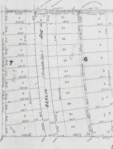
This claim’s accuracy is in doubt. All the alleys are marked as on the 1905 plat map are marked as “Private Alleys”. Here is an example from where you can clearly see the alley between Pershing (labeled Berlin) and Waterman is marked as “Private Alley”, the same as the alley behind Westgate. The part that is owned by Parkview is on Southern edge (left side of map) of the neighborhood labeled “Strip 15′ wide reserved by Beredith Realty Co.” clearly labeled different from the other private alleys.
The other reason this claim is not accurate is evidenced when you look at references to “private alley” in the indentures.
“Provided, however, and it is hereby expressly agreed that the cost of constructing and reconstructing any Alley or Alleys in said sub-division including the cost of grading, regrading, preparing the roadway for all the superstructure, placing foundation and road-way, and paving of such Alley or Alleys, shall not be included in the annual amount required or permitted to be assessed against the whole sub-division as aforesaid, but whenever said Trustees shall decide to construct or reconstruct any private alley in any Block in said sub-division, they shall estimate or cause to be estimated the total cost of such construction or reconstruction in such Block, and the owner or owners of each lot in such block shall be required to pay in advance on account of such lot, such proportion of said total cost as the frontage of such lot above stated or assumed bears to the total frontage of all the lots in said Block above stated or assumed.”
“CLAUSE H. The Northern boundary of the sub-division here-in-before mentioned or dealt with is the public alley shown on said Plat and extending from Skinker Road to Melville Avenue; the Eastern boundary is Skinker Road; the Southern boundary from Skinker Road to point opposite Lot 13 Block 7 where the right of way of the St. Louis, Kansas City and Colorado Railroad Company is diminished to a width of forty (40) feet is a line which runs parallel with and is distant fifteen (15) feet northwardly from said right of way, and from thence runs westwardly parallel with and twenty-five (25) feet northwardly from the Northern line of said diminished right of way to the Western line of said sub-division; and the Western boundary line of said sub-division is the Western line of the private alley which is shown on the aforesaid Plat as extending from Bonhomme Road or Delmar Avenue to the Southern line of said sub-division along the rear of the lots in Blocks 9 and 8 of said sub-division; and no property outside of said line is intended to be embraced in said sub-division.”
The first reference is using “Private Alley” to describe all alleys in Parkview. The second reference to “public alley” is to describe the only public alley servicing Parkview. The third reference and the second using “private alley” is referring to the Westgate alley. Notice how the indentures used the same phrase, “private alley” to describe all alleys that are contained within Parkview as opposed to the “public alley” not in Parkview. The statement by the agents appears to be wrong. We will have to give them a chance to explain these inconsistencies.
Claim: The next point they use to justify Parkview ownership is the dotted line that down the middle of the alley is:
“The 1905, 1911 Amended Plat, and the St. Louis County Plats show the Westgate lots terminating at the “Private
Alley 15’ W, 535’ L.” In contrast, the same plats show Parkview’s interior lots terminating in the middle of the alleys behind those houses (and as such, those homeowners are being assessed for the alley repair).” – from the Q&A supplied by the agents.
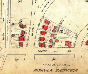
This claim is not accurate either. The straight line down the middle of the alley is the only difference in the way the Westgate vs interior lots are drawn. The plats show Parkview’s interior lots terminating with a dotted line at the edge of the alley with a straight line down the middle of the alleys behind those houses. The Westgate houses show the same dotted line terminating lots. The reason the straight line down the middle of the ally does not exist is because Westgate does not share their alley with an adjacent neighbor so there is no reason to divide the alley – the entire alley is included in the lot. Notice how all the houses have a dotted line in the front? It’s needed to show where neighbors share a border.
The last reason they have given us is that the lots are defined with measurements stated on the plat map.
“As an example on how to read the plats, Lot 5 in Block 8 (337 Westgate) is defined as a lot
51’1/2” wide at the front and extends back 153’1/2 inches from the inside of the sidewalk to
rear of property – marked by a dashed-line and by “v” marks (circled in red) – and is 50’” – from the Q&A supplied by the agents.
I’m not sure what this proves. Yes you read plats that way. Are both interior and Westgate lots in this picture are measured that way? What is the difference I’m looking for? We should get it measured to see what the interior lot on Center Ave in this picture measures from the interior of the sidewalk to the edge connected to the alley. Maybe the agents would like to clarify what the point is here.
A. So far we have been given no valid reason to believe the Westgate alley’s alleged ownership should be treated any different than the rest of the private alleys in the neighborhood. If there is more evidence to support their ownership claim, it has not been presented yet.


